|
The
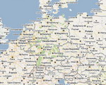
Eifel is a low mountain range in
western Germany. It occupies parts of southwestern North
Rhine-Westphalia and northwestern Rhineland-Palatinate.
The
Eifel is bordered by the Mosel River in the south and the Rhine in the
east. In the north it is limited by the hills of the High Fens (Hohes
Venn), in the west by the Ardennes of Belgium and Luxemburg.
There
are several distinct chains within the Eifel.
- The northernmost parts
are called Ahrgebirge and rise north of the Ahr River in the
district of Ahrweiler.
- South of that river
there is the Hohe Eifel ("High Eifel"), with the Hohe
Acht (747 m) being the highest mountain of the Eifel.
- In the west, on the
Belgian border, the hills are known as Schneifel (originally
Schnee-Eifel, = "Snowy Eifel"), rising up to 698 m. Also
in the west, by the Belgian and Luxembourg border, the region is
known as Islek (Aquilania).
- The southern half of
the Eifel is less high. It is cut by several rivers running
north-south towards the Mosel. The largest of these rivers is the
Kyll, and the hills on either side of this river are called the
Kyllwald.
- In the south the Eifel
is concluded by the Voreifel above the Mosel.
|